Back جسر ووترلو Arabic كوبرى واترلو ARZ Vaterloo körpüsü Azerbaijani Мост Ватэрлоа Byelorussian Ватерло (мост) Bulgarian Pont de Waterloo Catalan Waterloo Bridge Czech Ватерлоо (кĕпер) CV Pont Waterloo, Llundain Welsh Waterloo Bridge Danish
Waterloo Bridge | |
|---|---|
 | |
| Coordinates | 51°30′31″N 0°07′01″W / 51.5086°N 0.1169°W |
| Carries | A301 road |
| Crosses | River Thames |
| Locale | London |
| Named for | Battle of Waterloo |
| Maintained by | Transport for London |
| Heritage status | Grade II* listed structure |
| Preceded by | Hungerford Bridge and Golden Jubilee Bridges |
| Followed by | Blackfriars Bridge |
| Characteristics | |
| Design | Box girder bridge |
| Total length | 1,230 feet (370 m) |
| Width | 80 feet (24 m) |
| Longest span | 233 feet (71 m) |
| History | |
| Opened | (first bridge) 18 June 1817 (second bridge) 11 March 1942 |
| Location | |
 | |
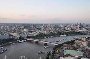
Waterloo Bridge (/ˌwɔːtəˈluː/[1][2]) is a road and foot traffic bridge crossing the River Thames in London, between Blackfriars Bridge and Hungerford Bridge and Golden Jubilee Bridges. Its name commemorates the victory of the British, Dutch and Prussians at the Battle of Waterloo in 1815. Thanks to its location at a strategic bend in the river, the bridge offers good views of Westminster, the South Bank and the London Eye to the west, and of the City of London and Canary Wharf to the east.

- ^ "Definition of 'Waterloo'". www.collinsdictionary.com. Retrieved 29 May 2020.
- ^ "Definition of Waterloo noun from the Oxford Advanced Learner's Dictionary". www.oxfordlearnersdictionaries.com. Retrieved 29 May 2020.
© MMXXIII Rich X Search. We shall prevail. All rights reserved. Rich X Search